Yuou can download the pdf of this document pdf here (47 KB)


The sudden resignation of the most adamant defender of hunting and fishing on the California Fish and Game Commission could put the finishing touches on a sweeping philosophical shift in the way the state views wildlife, sets rules for fishing and controls predators like mountain lions and wolves.

CHAOS AT FISH & GAME

Wolf conservation plan drawn up for California

Sour talk as lawmakers, crabbers meet over Dungeness shutdown

Wildlife advocates expand target after bobcat ban

Commissioner Jim Kellogg retired in late December in frustration over what he termed a lack of consideration for the sportsmen and women he represents. The resignation — combined with the unrelated recent departures of commission President Jack Baylis and Sonke Mastrup, the commission’s executive director — sets the stage for Gov. Jerry Brown to appoint conservationists to the increasingly pivotal state board.

Such a move may, observers say, complete the transformation of the commission from an organization that advocates for fishing and hunting to one that safeguards endangered species, preserves habitat and protects California’s top predators from slaughter.

But it won’t happen without a fight. While environmentalists say they are finally getting a fair shake in the high-stakes political game of wildlife management, advocates for outdoor sports fear that they have lost their voice and that the role they have played in the protection of species is being forgotten.


Trout Unlimited
SPORTSMEN FOR CONSERVATION - CALIFORNIA

Hello Fellow Sportsmen and Sportswomen:

As anglers and hunters, we know that quality habitat is the key to quality fishing and hunting.  We also know that many of our best fishing opportunity in this country are found on public lands - especially our national forests.

We now have a good opportunity to better protect some of California's best backcountry fishing and hunting opportunity.

The Forest Service is seeking public feedback on the agency's preliminary Wilderness Evaluation and Wild & Scenic Rivers Inventory for nearly four million acres of National Forest lands in the eastern and southern Sierra Nevada. The final evaluation and inventory will be included in the Forest Plan Revisions for the Inyo, Sequoia, and Sierra National Forests sometime later in 2016.

Trout Unlimited urges all sportsmen to weigh in on this process and support permanent protection of some of our most scenic and sensitive backcountry areas.

Fishing and hunting are allowed in all designated Wilderness and Wild and Scenic River corridors.  These designations are good for fishing and hunting because they strenghten protections for high value habitats (i.e., headwaters and alpine meadows).

The good news is that the Forest Service has significantly improved its evaluation of potential Wilderness and inventory of potential Wild & Scenic Rivers from last year, based in part on input from Trout Unlimited. The evaluation and inventory will be the basis for any recommendations the agency may make in the Forest Plan Revisions to ultimately provide permanent protection for some of the best fisheries in California.

This won't happen unless the public demonstrates its early support for protection for these scenic and sensitive areas, including strong support from sportsmen.

WILD AND SCENIC RIVERS
The Forest Service identified about 870 miles of rivers and streams on Sierra, Sequoia and Inyo National Forests that may be eligible for Wild & Scenic designation. Some of our favorite fisheries that would be bettter protected are:


SIERRA: Bear Creek, Mono Creek, North Fork Kings River, San Joaquin
SEQUOIA: Lower Kern, Little Kern, North Fork Tule
INYO: Hot Creek, Rush Creek, McGee Creek, Golden Trout Creek

WHAT WILD AND SCENIC ELIGIBILITY MEANS
All river segments determined eligible must be managed as such by the Forest Service until officially designated.

Interim management direction will be included in our forest plans to protect the segment's free flow, water quality and outstandingly remarkable values. This includes more stringent forest use guidelines on grazing, logging and other practices that can compromise the rivers' remarkable values.


*Wild and Scenic designation DOES NOT prohibit or reduce stocking for recreational fishing, or preclude recreational fishing.

WILDERNESS
The Forest Service has identified nearly 1.5 million acres of land in the Sierra, Sequoia and Inyo as having Wilderness qualities and is now consideringapproximately 495,000 acres for potential Wilderness designation. 
  • Expansions to the existing Domeland, Golden Trout and South Sierra Wilderness areas on both the Sequoia and Inyo Forests - all important headwater areas for CA golden trout and Kern River rainbow trout.
  • Important additions to the existing Monarch Wilderness on the Sierra and Sequoia Forests which will protect water quality and biotic integrity of the Wild & Scenic Kings River.
  • Scenic additions to the John Muir and Dinkey Lakes and Devil Gulch Wilderness that would help protect much of the Wild & Scenic South Fork Merced River on the Sierra National Forest.

*NOTE: Areas considered for new Wilderness are largely or entirely roadless -- Wilderness designation will not eliminate or reduce access to these lands.

LEARN MORE

Early Adopter Forest Plan Revision:http://www.fs.usda.gov/detail/r5/landmanagement/planning/?cid=STELPRD3802842

Wild and Scenic Rivers Evaluation:http://www.fs.usda.gov/detail/r5/landmanagement/planning/?cid=STELPRD3833668

Wilderness Inventory:http://www.fs.usda.gov/detail/r5/landmanagement/planning/?cid=STELPRD3803608

HELP! ACT AS A SIGNATORY
Trout Unlimited will submit a formal letter supporting permanent protection of qualifying habitats in these three national forests as designated Wilderness and Wild and Scenic River segments.  Please help us by co-signing our letter as an individual, organization or business.   To do this, please contact:


Jessica D. Strickland, TU California Field Coordinator 
This email address is being protected from spambots. You need JavaScript enabled to view it. 
830.515.9917


RESPONSE NEEDED BY COB FEB. 1


BACKGROUND INFORMATION
Wild and Scenic Rivers Act
In October of 1968, the Wild and Scenic Rivers Act pronounced:

"It is hereby declared to be the policy of the United States that certain selected rivers of the Nation which, with their immediate environments, possess outstandingly remarkable scenic, recreational, geologic, fish and wildlife, historic, cultural or other similar values, shall be preserved in free-flowing condition, and that they and their immediate environments shall be protected for the benefit and enjoyment of present and future generations."
Wilderness Act
The Wilderness Act, signed into law in 1964, created the National Wilderness Preservation System and recognized wilderness as "an area where the earth and its community of life are untrammeled by man, where man himself is a visitor who does not remain."

The untrammeled nature of wilderness often provides some of the best hunting opportunity while also serving to protect the headwaters of our favorite rivers.
TU'S FAVORITE FISHING HOLES
http://emailimages.tumembership.org/chapter_images/0000/1234/HotCreek_MammothCreekConfl.jpg
 

Hot Creek, Inyo NF
http://emailimages.tumembership.org/chapter_images/0000/1235/Kern.JPG
 

Kern River, Sequoia NF
http://emailimages.tumembership.org/chapter_images/0000/1236/004DECDD-2628-4814-BABE-5F275575F245.JPG
 

San Joaquin headwaters


™ 2014 Trout Unlimited | http://www.tu.org | https://www.facebook.com/TUCalifornia

This past weekend, Eternally Wild, the CalTrout and Keith Brauneis Productions film, premiered as one of the official selections of the 2016 Wild & Scenic Film Festival.

Now it's your turn to enjoy.

We're pleased to share with you the story of the iconic Smith River, a salmon and steelhead stronghold, its history and its current plight.

Here there are no dams, no wretched clear-cut blocks, no mitigating hatcheries. Instead... ancient forest, iconic redwoods and a powerful symbol of freedom -- THE SMITH.

But 4,000 acres of the pristine North Fork are threatened by a giant toxic nickel mine operation.

The Red Flat Nickel Corporation has applied to sink 59 drill holes that would pave the way for one of the largest nickel mines in the Western United States. The film examines current conditions, discusses future threats and asks just how much protection is enough?


Eternally Wild from California Trout on Vimeo.

I follow several blogs on the web. Chi Wulff is one blog that I follow it is out of Boseman, Montana. On January 3rd they had this video on Rush Creek. It is a remake from the first one that the Mammoth Fly Rodders put out in the 1990’s. This battle against the LADWP was a huge deal, a David and Goliath size fight. A bunch of fishermen fought the LADWP and won. Part of the settlement was to keep a minimum flow and do restoration of the seven miles from Grant Lake to Mono Lake. They only did two miles of stream restoration. Caltrout was a small organization back then with most of their help being volunteer. That’s how far back it was.


The settlement was turned over to Caltrout several years ago. From what I have heard Caltrout has told LADWP that the requirements of the settlement has been fulfilled. Caltrout’s stance is let’s let nature take its natural course. Problem with that is the dam at Grant Lake. If we get the El Nino that is predicted the LADWP will fill Grant Lake up. They will maintain that minimum flow. Rush Creek won’t get the spring runoff surges like the surrounding creeks will. So there won’t be the scouring and cleaning out of silt on the bottom of the creek. I talked to the CDFW about Rush Creek and asked if fishermen could fulfill the last five miles of restoration. The CADFW told me that the settlement hadn’t been released from the courts. I don’t know exactly what that means but nothing can be done until it is released. What some of the fishermen want to do is make some deeper holes like was done at the top two miles. This will give the trout refuge in the summer from the heat. This has been done in Idaho and other places with very good results.

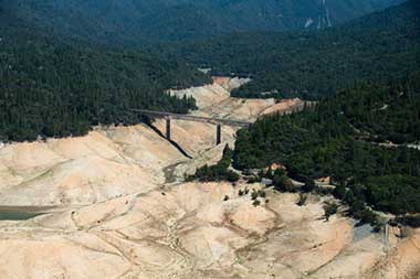
Two things caught my eye on this blog, 1) the photo of Lake Oroville (largest in the state) and 2) their talk of the drought and how it is probably going to become the norm. So here’s the first paragraph and photo. Click the link below to read the whole article. It will take you to their website and at the bottom there are links to other articles.

The banality of California’s ‘1,200-year’ drought

cwb

The south fork of Lake Oroville, California’s second largest reservoir,
in September 2014. Photo by Kelly M. Grow/California
Department of Water Resources


By Jay Lund

California’s ongoing drought will continue to break records and grab headlines, but it is unlikely to be especially rare from a water policy and management perspective.

Estimates of the current drought’s rarity range from once in 15 years to once in 1,200 years (Griffin and Anchukaitis 2014), depending on the region and indicators used (precipitation, stream runoff, soil moisture or snowpack). In the Middle Ages, large parts of California had droughts far worse than this one, some lasting more than a century (Stine 1994). The probability of California experiencing a once in 1,200-year drought during a short human lifetime is extremely low.

Read More: California Water Blog


By Gary Applebee

Last weekend after the Steelhead Science for Anglers symposium there was a meeting at Chili’s for a new conservation group. Well, not really a new group just a concerted effort to get many different people working together instead of separately on the San Gabriel River Monument. If you haven’t heard, President Obama signed a bill to make the San Gabriel Rivers into a monument. This encompasses the West Fork, North Fork, and the East Forks of the San Gabriel Rivers as well as some of the forest around the rivers.

The group talked about some of the problems on the San Gabriel River Monument. One of the members from the Pasadena Casting Club said the West Fork was being used as a city park. I thought that was a pretty accurate description of the West Fork’s usage. People walk and ride bikes up along the paved road that follows the river. On the weekends there can be up to 20,000 people swimming and playing in the river, FRVC and the USFS’s numbers. The flows on the West Fork River are down to a trickle. Pot Farms are on all three forks as they are on all our rivers. They talked about the numbers of people that are homeless and living up on the East Fork. Some of them are miners and some are squatters. The over use of Bungee America was discussed. Bungee America can have 200 or more people going back a day to bungee jump the Bridge to Nowhere. They discussed the proposed Cattle Canyon Project that will be coming up on the East Fork Canyon. There are problems of mining and pot farms up Cattle Canyon as well. If you grew up fishing the West Fork as a kid then this is something you might want to get involved with.

I met Jim Burns from LA River Fly Fishing: http://lariverflyfishing.com whose motto is; Fishing for carp, waiting for steelhead. I hadn’t heard of his blog, but read it after this meeting and I like his writing, give it a read. He’ll be writing for this group as well. I’ll be passing on their news blasts as they come.
I had hoped this would be a foothills group that would look at the problems of San Antonio Creek, Lytle Creek, Deep Creek, Santa Ana River, and Bear Creek. But, as you can see by the name they pretty much only want to talk about the San Gabriel River Monument. Don’t get me wrong, this is a good thing and if you fish on any of the three forks of the San Gabriel Rivers, it is long over due. Was I disappointed, maybe a little? I could list the problems creek-by-creek, but if you have fished locally you know what they are, the flows are down on all our creeks, people fishing the creeks in 100 degree weather, painting graffiti on the rocks, having parties on and in the creek then leaving their trash, silt accumulating, pot farms, and using these creeks for target practice. These aren’t issues only on the San Gabriel River. They are issues for all our creeks.